|
|
|
|
All armies use a system of codified symbols to enable command staffs to mark paper maps, sand tray mock-ups and computer displays to be marked in such a way as to show what military forces are doing at the moment, what has been planned for them to do or if a particular event has happened, such as a nuclear explosion or a unit's movement (1).
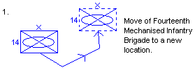
Move of Fourteenth Mechanised Infantry Brigade to a new location
They can also show some basic information about the forces themselves, such as a unit's location, ID, role, type and size (2) or a weapon's type, caliber and location (3, 4).
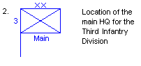
Location of the main HQ for the Third Infantry Division
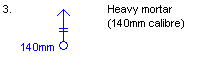
Heavy Mortar (140mm caliber)
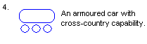
An armoured car with cross-country capability
The most common system is that developed by the NATO alliance, and used by its member states, the states that have joined the Partnership for Peace and an increasing number of non-member states, such as Australia and New Zealand. The second most widely used system is that of the Russian Army, employed by a number of the former Soviet states and Warsaw Pact countries. Most other countries use nationally-developed systems. Many of these share symbols that are quite close, while others are completely different (5). In addition, by using the same system of tactical symbols, the hierarchical organisation of a particular unit can be shown, in a sort of family tree style (6).
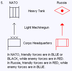
In NATO, friendly forces are in BLUE or BLACK, while enemy forces are in RED. In Russia, friendly forces are in RED, while enemy forces are in BLUE.
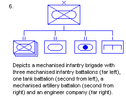
Depicts a mechanised infantry brigade with three mechanised infantry battalions (far left), one take battalion (second from left), a mechanised artillery battalion (second from right) and an engineer company (far right)
As such, displays that include a great deal of information can be built up using this relatively simple method. While this sort of symbology is obviously used a great deal in today's armed forces, it can also be seen in the wargaming and simulation arena, not so much in the traditional miniatures wargames, which represent military units by actual figures (if infantry of cavalry) or models (if artillery or AFVs), but in board and computer wargames. Board wargames, from companies such as SPI, Avalon Hill, Decision Games, Victory Games and 3W, represent a particular conflict, campaign or battle on a 2D representation of the battlefield that shows important terrain details such as topography, the road and rail infrastructure, built-up areas, rivers, swamps and marshland and are vaguely similar to an Ordnance Survey map, but usually stylised and incorporate a hex grid to regulate movement and combat. The military units are represented by cardboard counters that often have the NATO symbols on them to let the player know what the unit is, as well as having numeric qualities, such as 'attack strength', 'defence strength' and 'movement allowance' in order to govern how the unit performs in the game. The same is true for slightly older computer wargames (and true military simulations), but the more modern computer wargames such as Blitzkrieg, Codename Panzers, Combat Mission and Soldiers: Heroes of World War II follow the 'Command and Conquer' pattern of having 3D battlefields and units represented by 3D figures, being almost a computer miniatures wargame.
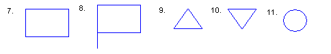
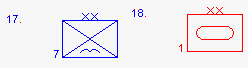
The basic unit symbol is a rectangle, with the lengths of the horizontal and vertical lines having a ratio of approximately 3:2 (7). A variation on this is the symbol for a headquarters unit (8) that has a vertical line dropping down from the left corner (so it looks a bit like a flag). Other basic symbols include an equilateral triangle with the point upwards for an observation post (9), an equilateral triangle with the point downwards for an electronic unit (10) and a circle for a logistics / administrative unit (11).
Unit size details are usually placed on top of the rectangle and are represented by a series of dots and vertical lines (12) for units that are of regimental-size or below, or crosses (13) for units that are of brigade-size or above.
 Nato Map Symbols: Regiments and smaller
![]() Nato Map Symbols: Brigades and above
Nato Map Symbols: Brigades and above
For certain arms of service, the particular term for the size of unit differs from that used in the infantry, such as armoured or cavalry units, where a platoon-sized unit is often referred to as a troop and a company-sized unit is often referred to as a squadron. Also, the term 'regiment' can refer to three different types of unit. It can refer to what used to be horse-equipped (i.e. non-infantry) battalion-sized units, such as an armoured, cavalry or artillery unit, for example, 40th Field Regiment, Royal Artillery or 35e Regiment Artillerie Parachutiste. Alternatively, it can refer to a tactical infantry unit made up of between two and five battalions but without the same level of supporting arms as is usually associated with a brigade. An example of this is a US Marine Corps Infantry Regiment that contains three Marine Infantry Battalions but becomes a Marine Amphibious Brigade when it is allocated supporting assets. Both the brigade and regiment can be used to form a division, for example, through much of the Cold War, countries within the NATO Alliance tended to use brigades as sub-components of their divisions, whereas members of the Warsaw Pact tended to use regiments. Lastly, some armies have the regiment as an administrative organisation, which is responsible for organisation, manning, personnel matters, welfare and traditions (such as the British Army), but which does not itself go to war - the individual battalions go into the field. A brigade is usually a direct sub-unit of a division that is self-sufficient unit with infantry, armour, artillery, engineers and army aviation (obviously one arm will dominate depending on the exact type of brigade it is) with its own logistics and administrative units. In some armies however, a brigade is a temporary unit, formed from divisional assets to perform a specific mission.
Within the rectangle, is shown the unit (14a) or weapon (14b) type, the three basic symbols being the infantry (a diagonal cross representing their webbing cross-straps), tank or armoured (a stretched circle representing the caterpillar tread) and artillery (a circle representing a cannon ball). Many of the unit symbols available are variants of these, although a number of additional symbols are used as well. For example, mechanised infantry is represented by a combination of the infantry and armour symbols, whereas parachute infantry often have the infantry symbol with an additional 'bird' symbol underneath.
![]() Nato Map Symbols: Units by type
Nato Map Symbols: Units by type
 Nato Map Symbols: Units by equipment
A unit's location is usually assumed to be at the centre of the lower edge of the symbol, or sometimes a line can be drawn from the centre of the lower edge to where the unit is if its necessary to offset the symbol (15).
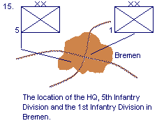
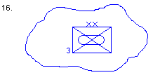
The location of the HQ, 5th Infantry Division, and the 1st Infantry Division in Bremen
Also, if a unit is spread out and covering a larger area than normal, its area can be indicated by drawing a 'blob' with the unit symbol at the centre (16).
In NATO, the designation of friendly units is indicated by them being blue (17), while enemy forces are red (18).
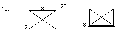
If its on a monochrome display, friendly forces are indicated by a single-lined symbol (19) and enemy forces by a double-lined symbol (20).
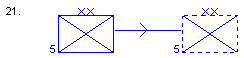
If indicating a unit in its current position, the unit is shown with solid lines, if it is showing a future position, the lines are broken (21).
The unit title is usually placed on the left-hand side, either in the centre or at the bottom corner and must agree with the unit type and size symbols (22).
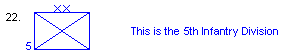
The Fifth Infantry Division
In addition, the identification of higher formations can also be placed on the symbol, on the right-hand side, either in the centre or at the bottom corner (23).
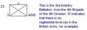
This is the 3rd Infantry Battalion, from the 4th Brigade of the 5th Division. '0' indicates that there is no regimental-level (as in the British Army, for example).
The higher formations are listed in the order of battalion, brigade, regiment, division, corps and army, separated by a '/'. If it is necessary to show the time, a date / time group (DTG) is placed at the top left-hand corner of the symbol and consists of up to six figures and three or four letters (24).
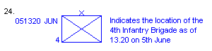
Indicates the location of the 4th Infantry Brigade as of 13.20 on 5th June
The first two numbers show the date (prefixed with a 0 if between 1 and 9), the next four numbers show the time (using the 24-hour clock), this is then followed (if necessary) by a letter denoting the time zone and finally, three letters indicating the month. The DTG on its own is used to denote the time and date that the unit was known to be at that location. It may also be prefixed by the letters 'NMB' (No Move Before), or possibly the length of stay by having 'From (DTG)' on one line, followed by 'To (DTG)' on a second line. If necessary, a mobility indicator can be placed beneath a unit to show the the type of mobility the unit has i.e. wheeled, tracked or ski.
In some instances, a boundary can be shown between units, for example, if units are tightly packed covering a common frontage (25). This is more common for maps and diagrams covering higher-level formations, such as one depicting corps and army level formations on the Eastern Front during the Second World War or in Germany on NATO's Central Front during the Cold War. Where a boundary separates two units of different size, the symbol for the larger unit will ordinarily be shown. The exception is where a unit rear boundary is shown that will show the size symbol of the unit concerned and not the symbol of the larger unit.
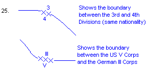
In drawing such maps, left and right are always defined when facing the enemy, boundaries are referred to by the senior unit to which they apply, for example, the boundary between the divisions in two separate corps is referred to as the inter-corps boundary. Finally, the nationalities of NATO countries is designated by a two-letter group and many non-NATO countries are designated using a three-letter group. For example, United Kingdom - UK, United States - US, Turkey - TU, Greece - GR, Spain - SP, Portugal - PO, Norway - NO, Netherlands - NL, Luxembourg - LU, Italy - IT, Germany - GE, France - FR, Denmark - DK, Canada - CA and Belgium - BE.
'Basic Military Map Symbols' in Lee, U. The Employment of Negro Troops, Center of Military History, US Army, Washington DC, 1966, CMH Pub 11-4, p. 715. Also available at http://www.army.mil/cmh-pg/books/wwii/11-4/symbols.htm as of 17 May 2006.
Military Map Symbols Webpage, part of the HyperWar Website, currently located at http://www.ibiblio.org/hyperwar/maps/MapSym.html as of 17 May 2006.
Miller, D. NATO Military Map Symbols Handbook, International Defence Review Quarterly Report, Number 1, Jane's Information Group, 1996.
Mouat, T. MapSymbs Homepage, currently located at http://www.mapsymbs.com/ as of 17 May 2006. 26: Example Division