|
|
|
|
The Allied Plans (1): Olympic
The Allied Plans (2): Coronet
While the overall plan for the invasion of the Japanese Home Islands was codenamed Operation Downfall, it was made up of two component operations, Olympic and Coronet. Many of the operations in the Pacific War were undertaken in order to not only eliminate centres of Japanese resistance but to provide bases for up-and-coming operations. So it was with Olympic and Coronet. The Operations in the Philippines and Central Pacific (particularly against the Mariana Islands) were designed to provide forward bases for use by Allied forces invading Okinawa (Operation Iceberg) and Iwo Jima (Operation Detachment). Okinawa in turn was to provide the forward staging base for Olympic, the invasion of Kyushu, the southernmost of the Japanese Home Islands, which in its turn, would provide the staging base for Coronet, the invasion of the Tokyo Plain on Honshu and the final blow aimed at forcing the Japanese to surrender.
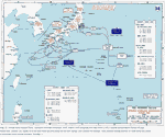
The fundamental concept behind Olympic therefore was to seize Kyushu (or at least the southern portion of it) for its airfields and bays in order to provide staging areas for the forces to undertake and support Coronet. As bases were secured, these air and naval forces would deploy forward to attack northern Kyushu, Shikoku and Honshu and to breach the Straits of Tsushima. Land-based airpower on Kyushu could bring the whole of Japan under attack while the navy could complete the blockade of the Home Islands. Olympic called for nine divisions formed into three corps to land simultaneously on three separate beaches, then drive inland to capture airfields and encircle Kagoshima Bay. A fourth corps of two divisions would form a floating reserve. The ground forces for Olympic would come from forces already deployed in the Pacific. I Corps would land at Miyazaki, XI Corps would land at Ariake Bay on the eastern side of the Osumi Peninsula. The three Marine divisions of the V Amphibious Corps would land on the western side of the Satsuma Peninsula near Kushikino. The floating reserve, IX Corps, would land at the southern end of the Satsuma Peninsula on X-Day plus 4 if it had not been committed elsewhere. After securing their lodgements, the invasion forces would move to accomplish three additional tasks – capture the interior plains of both peninsulas where the Japanese airfields were located, capture the port of Kagoshima as well as securing the shores and entrance to the bay, and drive northward to the southern edge of the central range of mountains to seal off southern Kyushu from the remaining Japanese forces in the north of the island. Allied forces would then secure a line running diagonally across the island from Tsuno in the east to Sendai in the west, thus securing the southern third of Kyushu (AFPAC Staff Study, ‘Olympic Operation in Southern Kyushu’, 28 May 1945, RG 165, NARA).
As mentioned previously, the main problem in the Pacific was shipping. The vast distances encountered in the theatre, the competing demands of other theatres (especially Europe) and enormous construction requirements all combined to produce a near permanent shipping shortage. Redeployment, the 'roll-up' and movement of rear areas and preparations for Olympic all added to the strain in the spring of 1945. The command staffs agreed that each command would be responsible for the procurement and operation of shipping under its control. The control of shipping and port facilities was a more pressing problem than the scarcity of shipping. Shipping requirements were carefully balanced – the control of tangled shipping networks and congested port facilities could create chaos and so elaborate procedures were worked out between AFPAC and POA to call forward shipping as needed and settling competing claims on port facilities. The three marine divisions would be transported and landed by Nimitz's command. Once ashore, items common to both the marines and the army would be supplied by AFPAC, items peculiar to the Marine Corps and Navy would be supplied by Nimitz, who would also support the marines' construction requirements.
The agreement on future planning simply extended the established practice of inter-command conferences. The detailed planning for the operation itself fell to Krueger's Sixth Army staff and Turner's Amphibious Forces Pacific staff. Turner's PHIBISPAC force would carry the assault forces from Sixth Army to their landing beaches and have command until Krueger's headquarters was established on Kyushu. Turner therefore sailed to the Philippines and on 14 June 1945 anchored his command ship USS Eldorado in Manila Bay right next to where the Sixth Army headquarters was encamped. On the same day that happened, a number of Marine officers, specialists in quartermaster, engineering, medical, intelligence, ordnance, transportation and signal arrived in Manila Bay to establish a liaison for V Amphibious Corps. There, along with the headquarters of Fifth Fleet (the command responsible for the landing force and gunfire support), they hammered out the detailed plans in a series of conferences – while each staff worked in its own headquarters, they resolved their differences and coordinated plans in a series of detailed planning conferences, working until the last week of the war. Towards the end, the conferences became almost continuous but eventually four detailed coordinated plans, each for Sixth Army, Far East Air Forces, Fifth Fleet and Amphibious Forces Pacific, emerged, along with detailed annexes regarding specialised subjects such as deception, communications and logistics. Once MacArthur and Nimitz had decided not to form a permanent inter-theatre planning group, the problem was then how they would correlate the different plans. Indeed, several months earlier, Marshall had raised this same question with MacArthur and suggested that he may want to relocate his headquarters with Nimitz for the invasion of Japan. MacArthur's reply was in the negative. On 6 June, Marshall relayed the suggestion from Admiral King that MacArthur move his headquarters to Guam so as to be in personal contact with Nimitz for the preparations for Olympic. MacArthur sent back "Please tell Admiral King that I disagree totally with his concept and that a long campaign experience has convinced me that if there is any one feature of a field commander that must be left to his sole judgement it is the location of his command post and the actual disposition of his own person." Finally, Nimitz tried to prevail on MacArthur to establish his advanced headquarters on Guam well in advance of the operation and promised he could furnish staff space and quarters for MacArthur comparable to his own. The reply remained the same.
The AFPAC Staff Study and CINCPAC study (AFPAC Staff Study, ‘Olympic Operation in Southern Kyushu’, 28 May 1945, RG 165, NARA; CINCPAC Staff Study ‘OLYMPIC’, 18 June 1945, RG 218, NARA) were completed by mid-June. These two preliminary planning documents contained the essential information that the lower echelon headquarters would need in order to draft the more detailed operation plans. The studies defined what the mission was, gave the concept of operation, outlined the command relationships and the rules for coordination and finally, listed the forces that would be employed. The forces to be organised and used in Olympic were mirrored in both staff studies. To carry out the naval and amphibious phases of the operation, Nimitz designated two fleets – the Third (under Admiral William Halsey) and Fifth (under Admiral Raymond Spruance). The Third Fleet that contained a large contingent of attack carriers that would provide almost two thousand aircraft to attack Japanese communications and transportation networks before the invasion and to cover the landings. The Fifth Fleet would carry the troops to the landing zones and provide gunfire support for the landings. Under Spruance came Admiral Turner (Commander Amphibious Forces Pacific) who would command the amphibious operations, with the Third, Fifth and Seventh Amphibious Forces, tasked with landing the assault forces at Ariake Bay, Kushikino and Miyazaki. MacArthur's counterparts two Halsey's and Spruance's fleets were the Sixth Army under General Walter Krueger and the Far East Air Forces under General Kenney. The Sixth Army would conduct the land campaign on Kyushu and the Far East Air Forces would support the invasion from bases on Okinawa and begin moving units forward onto bases on Kyushu from around X-Day + 2. The Sixth Army would also command the assault forces which were formed into four corps. Each corps was matched up with one of Turner's amphibious forces. I Corps, under Major General Innis P Swift would be transported to Miyazaki and put ashore by Seventh Amphibious Force. Lt General P Hall's XI Corps would be landed by Third Amphibious Force at Ariake Bay, while Major General Harry Schmidt's V Amphibious Corps of three marine divisions would be put ashore by the Fifth Amphibious Force on the Satsuma Peninsula. Major General Charles P Ryder commanded the IX Corps would be carried by the Reserve Amphibious Force and either reinforce one of the principle landing operations or if not needed, landed at the tip of the Satsuma Peninsula on or around X-Day + 4. As these plans were completed so the individual corps and amphibious forces began to draft their own plans, which were published in the last days of the war, with corps staffs starting to draft Olympic orientation briefings for their respective division staffs.
The preliminary phase of Operation Olympic would start five days before the main landings (X-Day – 5) and see the 40th Infantry Division as well as the 158th Regimental Combat Team (RCT) landing on a number of offshore islands in order to secure them for the construction of radar outposts, emergency anchorages and seaplane bases. On X-Day, unless the landings had to be staggered due to bad weather or other unforeseen events, the three corps (I, XI and V Amphibious) would simultaneously assault their respective beaches, as outlined above. IX Corps would act as the floating reserve, if necessary reinforcing one of the landings with the 98th Infantry Division, and if ordered to do so, land (with or without the 98th) on the south coast of the Satsuma Peninsula, east of Makurazaki anytime after X-Day + 3. Each corps would establish a beachhead and begin the reconstruction of roads and airfields. They would each then move inland securing more airfields as well as opening Kagoshima Wan for use by the US Navy, finally looking to eliminate enemy forces in southern Kyushu as they advanced northwards establishing a defensive line running across the island from Sendai on the west coast to Tsuno on the east coast. The operation was to be completed in ninety days and involve the 582,560 soldiers (of which 323,410 were combat troops) of Krueger's Sixth Army. (Sixth Army Field Order No. 74, Troop List, 28 July 1945, Records of the Strategic Plans Division, Box 187, NHC) The assault elements would land at beaches having codenames based on the United States premier obsession – motor cars. The potential landing areas in southern Kyushu were designated 'beach zones', having names that included Taxicab, Roadster, Limousine, Station Wagon, Town Car, Delivery Wagon and Convertible. In turn, each 'beach zone' was subdivided into possible landing beaches, with codenames that related to name of the 'beach zone'. Thus Taxicab had Zephyr, Winton, Stutz and Studebaker beaches. Limousine included Plymouth, Packard and Overland beaches; Station Wagon included Franklin, Ford, Essex, Dusenburg and De Soto beaches; while the Town Car zone included Cord, Chrysler and Chevrolet beaches. In the same way, the landing beaches designated for the 40th Infantry Division on Koshiki Retto were named after automobile parts – Brakedrum, Windshield, Cylinder, Gearshift, Hubcap, Rumbleseat, Sparkplug etc. Subdivisions of each beach were designated by colours and numbers, for example, Austin Yellow 1 and Austin Yellow 2. (Amphibious Forces Pacific Fleet Operations Plan No. A11 – 45, 10 August 1945, NHC)
At first glance, all the beaches that were on the map of southern Kyushu appeared inviting, with them being long and open, were relatively flat and were between fifteen and thirty kilometres long. It was the terrain behind the beaches that was of greater concern to the attackers. The landing beaches at Miyazaki, Ariake Wan, Kaimon Dake and Kushikino were all backed by rugged hills that were easily defendable and varied between fifty and two hundred metres in height. They stood between one and five kilometres behind the beaches and most ran the entire length of the beach. Corridors led away from the beach into the interior but themselves posed problems for any advance as anyone looking at small-scale maps might think that they led into the interior plains from the southern ends from both the Miyazaki and Ariake Wan beaches without any problems but were in fact dominated by heights that stood between ten and fifteen kilometres inland, while another range of rugged, broken hills lay immediately behind the beaches on Western Kyushu, particularly those near Kaimon Dake and Kushikino. Assaulting the beaches at Miyazaki was I Corps. From the beach, one can see the mountains that ring the triangular coastal plain, rising to a height of about 1200m and then heading inland, after two or three kilometres, one comes across a steep 50m bluff rising out of the plain that blocks progress down the corridor. It is here the Japanese placed a series of strongpoints sited to dominate the exits from the beaches. The corridor that exits the southern beaches towards Tano on the western side of the Honjo River was to be used as an entrance by US forces onto the Miyakonojo – Kanoya Plain. Near Tano however, there is an unbroken hill mass, rising 3 – 400m high and effectively blocking the corridor. Partitioning I Corps' landing area was the Oyodo River flowing down from the mountains with the Miyazaki airfield immediately south of the river's mouth, itself a prime objective. This layout would keep I Corps divided until it drove into Miyazaki to take the bridge across the river. The beaches in this area are long, gently sloping affairs with hard sand – ideal for amphibious operations. On 4 August 1945, I Corps published a tentative field order (I Corps Field Order, 4 August 1945, RG 94, Box 3089, File 201-3.9, WNRC) outlining the assault on Miyazaki. The plan outlined the landing of the 25th Infantry Division on Cord Beach south of the river's mouth and the 33rd Infantry Division north of it. The corps reserve would be the 41st Infantry Division and would stay afloat awaiting the order to act in one of three ways: to reinforce either of the other divisions; to follow-up the 25th on X-Day + 2; or to make an assault landing on Chevrolet Beach, immediately north of Chrysler Beach, to extend the corps beachhead. Both the 25th and 33rd would land with two regimental landing teams abreast with the 25th capturing Miyazaki airfield and then advancing south to clear any position with which the Japanese could directly fire onto Cord Beach and block any enemy advance from the south. Upon completing that task, the 25th would advance westwards down the corridor that runs towards Tano and through the mountains towards Miyakonojo where it would (hopefully) meets elements of XI Corps advancing north from its beachhead at Ariake Wan. The 33rd Infantry Division meanwhile was to capture Miyazaki itself, seize the main coastal highway and the bridge there and establish contact with the 25th Infantry Division to the south. It would then advance westwards to expand the corps beachhead and then north to take Hirose to block any enemy advance from that direction. I Corps planners noted a number of critical objectives that needed to be seized early in the campaign. These included the Miyazaki airfield, the coastal highway and the bridge across the Oyodo River (without which the corps would have no north-south communications) as well as several pieces of terrain including the ridgeline that lay two to three kilometres behind the beaches, a 100m high hill north of Miyazaki that provided observation over the whole area including Miyazake and Chrysler Beach and another hill just south of Cord Beach that could be used to enfilade the entire 25th assault area. I Corps would land, advance inland and secure the area from Sadohara in the north, through Honjo and Takaoka to Aoi Dake in the south. Even as the combat divisions would drive inland, hot on their heels would come the combat engineers and support troops of Army Service Command, Olympic, Base 3, to begin repairing and building airfields, storage facilities, bases and roads.
Ariake Wan (now Shibushi Wan) lies only 32 miles (51km) southwest of Miyazaki as the crow flies but in-between lies rough forested hills and mountains, up to 1,000m high with only a single road winding itself down the east coast. Even though Sixth Army had not designated XI Corps' assault as the main attack, the landings at Ariake Wan were still of importance to the overall success of the operation. Ariake Wan is a peninsula flanked to the east and west by 3 – 400m heights. The beach there stretches some fifteen kilometres along the coast and the small port of Shibushi at the eastern end makes it even more inviting for amphibious operations. A rapid advance inland from here would place the invaders on the Miyakonojo-Kanoya Plain, an area of great importance as it holds a great number of airbases and has access to the head of Kagoshima Bay. The area however holds some good defensive sites. Heavy guns could have been placed on both flanks with these heights providing excellent observation of the bay and the beaches. In addition, the small island of Biro Shima which lies five miles offshore and right in the middle of the bay would have provided a useful gun platform, allowing the defenders to fire at the invasion fleet and any of the beaches. The eastern half of the beach has a continuous ridge running behind it at a height of between 25 – 50 metres high at a distance of between 500 and 1000 metres. This ridge is cut in a number of places by streams coming down from the hills and is where the Japanese sited a number of strongpoints designed for all-round defence and linked by tunnels under the hills, manned by elements of the 86th Division. Heavy 150mm artillery pieces could fire from cave openings in the hillsides onto the beaches or stream valleys. The western half of the beach the Kushira River plain makes the terrain much flatter and more open with the main route to Kanoya running through the area. Moving into the interior however, there is another ridgeline at a distance of 15km (9 miles), averaging around 50m high upon which the Japanese positioned the 188th Infantry Regiment to block mobile forces coming off the beaches and into the interior. Conducting the assault would be Lt Gen Hall's XI Corps, composed of the veteran 1st Cavalry, Americal and 43rd Infantry Divisions plus the 112th Regimental Combat Team. On 6 July 1945, the corps Chief of Staff, Brig Gen John A. Elmore called together all his staff officers to begin planning the assault (XI Corps Staff Conferences on OLYMPIC, 6-9 July 1945, RG 94, Box 4159, File 2.11-0.5, WNRC). Logistics were of the greatest concern as not only were the divisions and all their equipment to be landed, over 35,000 tons of supplies had to be landed on and moved across the beaches in the first five days of the assault. Congestion on the beach was perhaps inevitable – the beaches could hold some sixty LSTs at any one time, about ten per mile. Elmore noted that if necessary they could be packed in 'gunwale to gunwale' but the allocation of space on the beach for supply dumps, bases, headquarters areas, casualty treatment centres etc needed detailed planning and close coordination with the Army Service Command, Olympic (ASCOM 'O') whose units would land right behind the combat units in order to start construction and repair of the bases that would accommodate the aircraft of the Far Eastern Air Forces (FEAF). Three days later, he called the commanders and staff of the 1st Cavalry Division, 43rd Infantry Division and 112th RCT to meet with XI Corps staff. The Americal Division staff, being far away in Cebu in the southern Philippines did not attend. The division received its orientation when General Elmore along with his G-2, G-3 and G-4 flew down to Luzon. While he could not offer a detailed scheme of manoeuvre as yet, while they would not have everything they wanted, they were "definitely out of the 'shoestring' department". In addition to the three divisions and single RCT, XI Corps would have four additional battalions of artillery, one battalion of antiaircraft artillery, two tank battalions, two amphibious tractor battalions, one tank destroyer battalion and two amphibious tank companies. The tank destroyer battalion would be equipped with 90mm rather than 75mm guns and six of the corps' 155mm artillery battalions would be self-propelled. All these powerful direct-fire weapons would be attached to the divisions as "caves, tunnels and other fortifications are encountered". All this additional firepower meant that XI Corps would be the heaviest going in, Elmore noting wryly "we are duly honoured". Final plans for the landing were never issued, however, some planning started to take place in early July and indicated a traditional two-up, one-back approach with the 1st Cavalry Division on the left, 43rd Infantry Division on the right, landing abreast at the head of the Ariake Wan. The role of the 112th RCT remained speculative when the war ended but it could have been placed in corps reserve to be used on one of the flanks or attached to one of the assault divisions. The Americal Division was to be the floating reserve and scheduled to cross the beaches anytime after X-Day + 2. The 43rd Division, landing on both Dusenburg and De Soto beaches was tasked with capturing Shibushi, along with its port and airfield. The division would then drive northwards along the corridor towards Miyakonojo and eventually link up with the 25th Infantry Division (from I Corps) driving westward from Miyazaki. 1st Cavalry Division meanwhile, landing on Ford Beach would advance westwards along a natural corridor towards Kanoya and the western shore of Kagoshima Bay. The end of the first phase would find XI Corps units on a line Aoki – Iwagawa – Takakuma – Kanoya (Sixth Army Field Order No. 74, Troop List, 28 July 1945, Records of the Strategic Plans Division, Box 187, NHC; and XI Corps Tentative Plan for AAA Employment for Operation OLYMPIC, 8 July 1945, RG 338, Box 17, Operations Reports and Related Records, 1944 – 46, WNRC). Such a foothold would achieve several objectives, such as the sheltered anchorages in Ariake Bay, the Japanese Naval airbases near Kanoya and Miyakonojo, where there was room for even more airfields. Japanese strategists were right in deducing that the landings at Ariake Wan presenting the gravest danger to southern Kyushu.
The beaches at Fukiagehama stretch in a 30km (19 miles) crescent along the western side of the Satsuma Peninsula and while very beautiful, presented the most difficult task for the Allied forces. The beach itself is hard white sand but is backed within about fifteen feet by ten-foot (3m) high dunes made of soft sand. Immediately behind the dunes is an area of scrub pine followed by an area between one and five kilometres deep that is solidly agricultural (ploughed and irrigated fields etc) and backed by high hills. These give way after about 10km (6 miles) to a range of small mountains, around 3 – 600m high, which are packed very closely together. These small mountains resemble areas of eastern Belgium, the Dalmatian coast of the former Yugoslavia or central Italy. Cutting through these mountains are three narrow corridors that lead across the peninsula towards Kagoshima, the shortest being 20km (12 miles). The northern few kilometres of Fukiagehama is cut off from the long beach by 20m cliffs. Between these cliffs and the city of Kushikino lie two more beaches, each only 2,000 yards wide. These beaches, codenamed Stutz and Winton, were the landing beaches for V Marine Amphibious Corps under Major General Harry Schmidt (Amphibious Corps Operation Plan, No. 1 – 45, 6 August 1945, USMC Geographic File, Japan, Box 52, WNRC). The Corps mission was to land in the Kushikino area, secure their beachhead that included Sendai and then block the advance of any enemy forces coming down the west coast. They would then advance inland to secure a line Kagoshima – Kawakimicho – Ichino – Sendai. The corps would land with the 3rd Marine and 2nd Marine Divisions abreast with the 3rd on Winton and the 2nd on Stutz. The divisions would land with two RCTs abreast with the 5th Marine Division acting as a floating reserve, prepared to reinforce either assault division or make a separate assault on Zephyr Beach to the north or Star Beach to the south. The 2nd Marine Division, after landing, would then drive southeast to block enemy attacks that might threaten the corps' right flank. By doing this, it would also secure the entrance to the narrow corridor that runs southeast across the peninsula towards Kagoshima, a route the division would have to take in order to capture the city. 3rd Marine Division would turn northwards towards Sendai to block enemy reinforcements coming south. The corps would then advance to secure the line Kagoshima – Sendai. Of all the landings, the Marines faced the toughest task. The beaches were backed by dues and they were then faced with having to cross the Ozato Gawa which ran parallel to the beach about 500 yards inland. Following this was rough terrain and rice paddies with hills up to 600 feet high providing observation of the entire beach. The roads running inland were incapable of taking a large amount of heavy traffic so the Marines would have had to be careful as to what they put on them and how much. As one V MAC planner put it, it would have been "an unpleasant landing at best." (Skates, p. 185)
IX Corps itself (under the command of Major General Ryder) lacked combat experience but still had to prepare for a whole host of possible contingencies. (IX Corps Field Order No. 1, Operation OLYMPIC, 12 August 1945, RG 94, Box 4105, File 209-3.9, WNRC) It was designated as Sixth Army's floating reserve and so was to conduct diversionary operations off Shikoku from X-Day-2 to X-Day. The 98th Infantry Division (another inexperienced formation) was to be prepared to reinforce any of the Sixth Army landings on or after X-Day+3, while the 77th Infantry Division (an experienced formation that had seen action on Guam, in the Philippines and on Okinawa) was to be prepared to do the same after X-Day+5.
The corps was also to prepare for contingency landings on the southwest tip of Kyushu from about X-Day+3 onwards. The designated beaches lay immediately west of the entrance to Kagoshima Bay and stretch westward from the bottom of Kaimon Dake, a near perfectly formed 3,000-foot volcanic cone. While the beach is around 10km long, only the eastern half is suitable for amphibious landings, the western half being backed by broken and rocky cliffs right down to the beach. The eastern half had hard, black sand but was backed by a low ridge, followed by a series of low hills, spread about in seemingly random positions. The small compartment-like spaces in-between were rice paddies. Open country opens out from behind the western end of the beach, heading towards the large airfield complex at Chiran, but the beach itself was unsuitable for amphibious landings. The two beaches selected for IX Corps were Packard Beach on the right and Plymouth Beach to the left. The 98th Infantry Division, unless committed elsewhere, would land on Plymouth Beach, drive north to seize Byu airfield and then continue its advance towards the airbase at Chiran. The 81st Infantry Division would land at Packard Beach, next to Kaimon Dake, drive straight across the peninsula to the shores of Kagoshima Bay and clear the area. The reconstruction of air and naval bases and facilities would begin almost immediately.
The 40th Infantry Division, enlarged by additions to its normal TO&E, numbering over 20,000 as opposed to just over 14,000, would be the first into battle during Operation Olympic. The division's mission was to seize a number of offshore islands to the south and west of Kyushu to capture radar sites, emergency anchorages and seaplane bases. On X-Day-5, elements of the division would assault Kuro Shima, Kuchinoyerabu Shima, Kusakaki Shima and Uji Gunto. On X-Day-4 the remainder of the division would land in the north and the south of Koshiki Retto, a large island group about thirty miles to the west of the V MAC beaches. In the same way, the 158th RCT was ordered to prepare to land, on or just after X-Day-5 on the north coast of Tanega Shima. This operation however would be contingent on the strength of Japanese air and naval defences in the Osumi Strait, the narrow channel between the Osumi Peninsula and Tanega Shima through which the amphibious forces supporting and carrying both I Corps and XI Corps would have to pass. The 11th Airborne Division, acting as the Sixth Army reserve, would embark in the Philippines on turnaround shipping and be available from X-Day+22. (AFPAC Operations Instructions No. 1/9, 3 August 1945, RG 338, Box 193, Sixth Army Engineer Section, Plans and Operations, 1943 – 45, WNRC) The divisions of the AFPAC Reserve, to be committed only on the express orders of General MacArthur, were designated on 03 August 1945. The 7th Infantry Division, stationed on Okinawa, would be ready by 10 November 1945 while the 6th Infantry Division (on Luzon) and 96th Infantry Division (on Mindoro) would be ready from around 20 November 1945. General Krueger's headquarters, on board the USS Eldorado, would move with XI Corps to Ariake Wan. After the corps headquarters moved ashore, Krueger would establish a temporary headquarters in the centre of the beach near Hishida. As the corps moved forward, the Sixth Army HQ would move inland to Matsuyama then to the Miyakonojo area. A permanent headquarters would eventually be established at Kokubu, near the top of Kagoshima Wan.
During the first months of the occupation of Japan, observers from both the V MAC and IX Corps went to southern Kyushu, studied the terrain as well as the Japanese defences and attempted to project the course of the battle had Operation Olympic been launched. Both sets of observers saw the rugged terrain of Kyushu as the chief Japanese defensive advantage and consequently the chief American problem. The rough terrain, along with the narrow corridors leading into the interior, substantially neutralised the massive American advantage of manoeuvre as their forces advanced inland. Yet both reports (V Marine Amphibious Corps Operations Report, Occupation of Japan, Appendix 3 to Annex C, 30 November 1945, Marine Historical Centre, Washington DC; IX Corps Report of Reconnaissance and Survey of Japanese Dispositions, Southern Kyushu (Operation OLYMPIC-MAJESTIC), 15 December 1945, RG 94, Box 4104, File 209-2.0, WNRC) concluded that Japanese preparations would still have been incomplete by the time the invasion, that Japanese transport, communications and supplies were completely inadequate and that Japanese plans for a rigid beach defence coupled with counterattacks from mobile forces further back in the interior would have been almost impossible to execute. Except for the gravelled national highways that ran down either coast, Kyushu roads were unimproved and incapable of handling heavy military traffic with many bridges being made of logs which were tied together with rope. Railways were better developed than roads, but these ran through many tunnels and defiles which would have been susceptible to air attack. Japanese military communications depended heavily on commercial telephones along with a few older radios and field telephones using unburied wire The required stocks of ammunition had not been accumulated to the necessary levels, and air attack would have disrupted internal transport and communications making the distribution of supplies very difficult and for the same reason, made the Japanese plans to move units stationed in the interior and Northern Kyushu southwards to mount counterattacks very difficult indeed. The massing of American ships in forward areas and the increasing rate of air and naval sorties would have made the invasion almost impossible to hide past about X-Day-10. The pre-X-Day operations by both the 40th Infantry Division and 158th RCT against the offshore islands would have provided near certain evidence that Southern Kyushu was the target of the invasion. The objectives of the 40th Infantry Division were guarded by a few outpost units and would have fallen easily although the 158th RCT would have faced a much sterner test on Tanega Shima which was defended by some 6,000 high-quality Japanese troops. Japanese defences relied heavily on fixed coastal guns, positioned to defend harbour entrances, ports and strategic narrows. Opening fire against the invasion fleet, while achieving initial surprise, would have allowed these defences to have been quickly destroyed either by naval gunfire or air bombardment. Indeed, many of the locations of these guns were already well-known to US planners.
The observers surmised that the landing operation would have been an easier task than actually pushing inland against the rugged terrain or along the narrow corridors leading into the interior. Given the weight of the landings by I Corps at Miyazaki and XI Corps at Ariake Wan along with air and naval support would have carried the beaches. It is likely that the Japanese would have attempted to commit forces from central Kyushu and to move the 212th Division (a coastal defence division) southwards to mount counterattacks but would have faced intense US air attack and assuming they arrived, would have probably arrived piecemeal and late. Both corps however would have faced heavy fighting as they moved inland, in the inland ridges facing I Corps or the high hills flanking Ariake Wan for XI Corps. However, XI Corps faced more open country than I Corps did around Miyazaki with a wide corridor leading from the southern end of the beaches right across the peninsula to Kanoya with another leading north towards Miyakonojo. Conversely, this same open country would have allowed the Japanese to more easily reinforce their forces around Ariake Wan. Again, these would have faced interdiction from American air forces and a rapid advance by XI Corps could have held these reserves north of Miyakonojo and would have allowed the Americans to use their superior mobility and firepower to greatest advantage. The marines of V MAC undoubtedly faced the toughest challenge of Operation Olympic. The terrain and Japanese defences would have proven formidable obstacles. Behind the beach lay a low ridge and behind that lay some open country which consisted of paddy fields and dominated by mountains and wooded hills, providing excellent sites for artillery and observation. The 3rd Marine Division had to swing left and force open the corridor to Sendai while the 2nd Marine Division had to swing southeast and move towards Kagoshima, both routes being dominated by high ground. On the other hand, each assault division would only be facing a Japanese battalion defending each beach, Japanese intelligence anticipating that the American landings would take place further south and thus deploying their larger units there. Thus as the 2nd Marine Division advanced towards Kagoshima, it would have faced pressure on its right flank from the Japanese 206th and 146th Divisions, especially it became obvious that they faced being cut off in the southern tip of the peninsula. Movement southward by the 303rd Division to prevent the advance of the 3rd Marine Division towards Sendai would have been difficult, given American air activity. The broken terrain, lack of mobility and US air interdiction would have probably made a concentrated defence against V MAC impossible and Japanese forces would have been defeated in detail, yet the Japanese could choose where to make their stands, where to place their defensive positions and where to place their forces. The terrain allowed very little manoeuvre by either side and so the marines would have to fight the Japanese were they found them. Sixth Army's advance to the Tsuno – Sendai line would have been slow, just by virtue of the terrain.
The XI Corps observers who examined their corps' objectives in the southern Satsuma Peninsula also found difficult terrain and problems with the local road network. Yet they found that after the war had ended, Japanese defensive preparations had hardly begun and none of the units that were supposed to be manning the defences were in place, with none scheduled to arrive before 1 October 1945. Among the units that were scheduled to deploy there, there were endemic equipment shortages and haphazard training. The units had made no plans to construct obstacles or lay minefields or conduct a defence in-depth. The 146th Division, the central coastal defence unit in the IX Corps area had been able to give rifles to only ten percent of its personnel and ammunition supplies were limited. The Japanese 40th Army, responsible for the defence of the V MAC and IX Corps landing areas had only 186 trucks, forty-six armoured cars and sixty-four 'other' vehicles. Half of these were inoperable due to lack of maintenance and the remainder had only limited range due to a shortage of fuel. Therefore terrain in the IX Corps area favoured the defenders but the observers found that the Japanese had done little to capitalise on this advantage, for little had been done to site gun positions and prepared defences on the enfilade positions of Kaimon Dake on the right of the landing beaches and the rocky peninsula to the left of the landing beaches or even on the rocky lowland immediately behind the beaches. In fact, the IX Corps observers saw the terrain and the lack of a decent road network as their chief obstacle. The black, hard volcanic sand on the beaches would allow 'dry' landings but the beach was backed by a continuous, tree-covered bluff, between 20 and 40-foot high. The only exits were narrow footpaths, thus requiring a major engineering effort to cut exits through the bluff and egress routes for the assault divisions from the beach. After that, the assault troops faced an intricate pattern of terraces interspersed with deep gullies, narrow ridges, foothills and villages. Such terrain would have made formidable natural defensive positions and only really required a reasonably equipped force to position itself appropriately to make the area a natural fortress. It was in this terrain that IX Corps had to establish a beachhead and develop attacks in two directions, one division moving towards the Imperial Japanese Army airfield at Chiran ten miles to the north, the other westwards across the peninsula towards the eastern shore of the Kagoshima Wan. Despite the rugged terrain, the IX Corps observers concluded that the weakness of the Japanese defences would have allowed IX Corps to fulfil its mission. Chances are, overwhelming American air, naval and land power would have prevailed, as it had done at Luzon, Iwo Jima, Okinawa and the Mariana Islands. Japanese defenders were very numerous but lacked prepared defences, adequate resources, mobility and lacked extensive training. The rough terrain of Southern Kyushu would have restricted the US ability to manoeuvre, slowed progress and probably caused the operation to fall behind schedule but would have handicapped the Japanese ability to move reinforcements into the battle area.
As mentioned previously, the basic idea behind the Pacific drive was that each operation would advance Allied forces towards their ultimate goal of Japan but also provide bases for subsequent operations. Just as Operation Iceberg brought Allied forces within striking range of Kyushu and from which planes based there could cover the whole of the island, so bases on Kyushu would allow aircraft to reach the Kanto Plain on Honshu. Following the invasion of Kyushu, a massive construction effort would begin to turn the southern portion of the island into a giant air, naval and ground base for the Allied forces marshalling for finishing the war against Japan. Aircraft could reach most targets in Japan while ground and naval forces could stage for Operation Coronet, the assault on Honshu, while the Navy could also reach the Tsushima Straits and complete the blockade of the Japanese Home Islands. Such an effort would have been immense, requiring tens of thousands of engineers. Indeed, a brigade of such troops would accompany each corps onto the beaches. Immediately behind the assault troops, even as the fighting continued, additional construction battalions would arrive to start the largest base-building effort yet seen in the Pacific, a theatre that required enormous construction and service resources, given the disparate and scattered nature of the objectives and lack of infrastructure. In the Sixth Army troop list, engineers numbered some 117,500, accounting for twenty-one percent of the army's strength and that didn't include navy construction units or other support personnel. All the combat units slated to take part in Olympic were already in the Pacific, but a large number of engineer and support units would have to be redeployed from Europe. Such redeployment would involve, engineer, construction, medical, port and quartermaster units, making up about fifty percent of the units supporting Sixth Army. Most would arrive through the Philippines and stage through Luzon. Others would arrive will the roll-up of units based in New Caledonia, the Solomons and New Guinea with others still coming straight from the continental USA. (Troop List of Service Troops to Stage through Luzon, 19 July 1945, RG 338, Box 59, Sixth Army G-4 Decimal File, 1943 – 46, File 4, WNRC)
Planners envisaged three giant base complexes, capable of supporting over 720,000 troops and 2,800 aircraft. The Sixth Army would begin construction as soon as it was feasible to do so and then on X-Day+30 turn over the construction effort to ASCOM "O", while CINCPAC worked on the naval facilities. Each base would include camps to house soldiers, covered storage facilities, bulk petroleum storage, hospitals and shops. Every effort would be made to repair and upgrade the existing road infrastructure as well as airfield construction or repair, the priority to be given to all-weather runway and command and control buildings. Dispersal areas and hardened shelters for aircraft would come later. (Engineer Annex to USAFPAC Operations Instructions No. 1, 20 June 1945, RG 338, Box 193, Sixth Army Engineer Section Plans and Operations, 1943 – 45, WNRC) Three base commands would be responsible for the construction and all the logistic support for the forces in their area, receiving, storing and issuing all the supplies for the units concerned. Additional supplies for Olympic would come directly from the USA with ships being pre-packed on the west coast. Each ship would be loaded with standard quantities of commonly used items, such as food, clothing, medical supplies, spares etc. Others would have the bulk items, such as ammunition, fuel and construction materials. These ships would start to leave the USA at intervals, weeks before the operation was to begin and be held in harbours all over the western Pacific (such as Okinawa) before being sent forward to the assault beaches as needed. Base Commands would also be responsible for the short-term hospitalisation of casualties after X-Day+15. By X-Day+90, the base commands would have had the facilities to take care of most casualties, except those requiring more than thirty days of hospitalisation. (Basic Logistic Plan, OLYMPIC, in Fifth Air Force Logistical Plan for Operation OLYMPIC, US Air Force Historical Center, Bolling Air Force Base, Washington DC) The largest of these commands would have been Base 1 in the Kagoshima area, built to house some 400,000 troops. This base would have served all the facilities in the Satsuma Peninsula, including the V MAC area. Four installations would have been built to hold 245,000 barrels of fuel, port facilities would have been expanded to house fourteen lighter craft, four small ships and ten Liberty ships simultaneously. Pipelines would have been laid to serve the facilities in the southern end of the peninsula and the combat units covering the stopline, running from Kushikino to Sendai and from Kagoshima to Kajiki. Engineers would build 900,000 sq ft of covered shop space, 1.8 million sq ft of covered storage and by X-Day+135 would have built hospitals totalling 13,250 beds. Base 2 would house 185,000 troops and be built in the Shibushi-Kanoya-Miyakonojo area. To serve the many airfields in this area, bulk fuel storage facilities able to hold 497,000 barrels would have been built, along with pipelines running from the terminal at Shibushi to Kushira, Kanoya and Takasu in the west as well as Iwagawa and Miyakonojo in the north. Dock facilities at Ariake Wan were limited but once Kagoshima Bay was opened, ships could dock across the bay in Takasu near Kanoya. Plans called for 1.25 million sq ft of covered shop and storage space and by X-Day+135, 15,500 hospital beds. In addition to all this, around 45,000 sq ft of headquarters space had to be provided in the Shibushi area to hold MacArthur's forward headquarters and its 1,000 personnel as well as an additional twenty-five buildings to hold communications and signals equipment. Base 3, located in the Miyazaki area, was to be the smallest of the three bases due to the lack of covered or sheltered anchorage facilities, only accommodating some 135,000 troops, housing bulk storage facilities for 121,000 barrels of fuel, 4,500 hospital beds and 150,000 sq ft of covered shop and storage space. (Engineer Annex to USAFPAC Operations Instructions No. 1, 20 June 1945, RG 338, Box 193, Sixth Army Engineer Section Plans and Operations, 1943 – 45, WNRC)
Nimitz himself planned to build a number of naval installations in the southern portion of Kyushu. The largest was planned for Takasu on the eastern side of Kagoshima Bay, near Kanoya Airfield. At Takasu, the Navy would build an artificial harbour, with piers to handle ten attack transports and a tanker simultaneously. The base would also be capable of repairing small craft, patrol boats and landing craft as well as having storage facilities of commonly used supplies such as ammunition and fuel. Covered storage of 1 million sq ft would hold supplies for servicing the fleet. Nearby, the Navy would adapt one of the airfields at Kanoya to accept planes from the Naval Air Transport Service. Smaller and more specialised facilities were planned for Uchinoura, a small bay on the southern side of Ariake Wan, at the mouth of Manose Gawa near the southern end of Fukiagehama as well as at Yamagawa ear the mouth of Kagoshima Bay. Uchinoura would serve naval forces operating near Ariake Wan, Manose Gawa would allow tankers to unload their fuel to the nearby marine air bases and Yamagawa would become a PT-boat base. All these facilities were to be operational by X-Day+120. (CINCPAC Operations Plan, OLYMPIC, USMC Geographic File, Japan, Box 50, Folder B1-1, WNRC)
The massive construction effort demanded by the consolidation of the American hold on Kyushu and the preparation of bases to hold the forces that would undertake Coronet placed great demands on engineering resources available to the planners. Sixth Army predicted unprecedented demands for engineers to support combat operations due to the poor roads and difficult terrain on Kyushu. When that demand was combined with the needs of the base building effort, there were simply not enough engineers to go around. Sixth Army Engineer Brigade General S D Sturges Jr was concerned that the construction programme outlined for the first sixty days of Olympic were far too ambitious. Even without any fighting, he argued, the programme timetable could not be met. He thought that the number of engineer units would have to be double in order to complete the programme to schedule. FEAF also complained that that the number of engineer construction units allocated to airfield construction was inadequate to allow the build-up of airpower laid out in the Olympic plans. General Kenney urgently requested that additional engineer effort be allocated to air force projects, a requested that was rejected by AFPAC citing that there would be a shortfall in engineer and construction resources in the objective area. (Memo, Sixth Army Engineer to Chief of Staff, 3 June 1945, RG 338, Box 59, Sixth Army G-4 Decimal File, 1943 – 1946; Letters, Allied Air Forces to CINCAFPAC, 3 August 1945 and CINCAFPAC to CGFEAF, RG 338, Box 191, File No. 5, Sixth Army Engineer Section Plans and Operations, 1943 – 1945, WNRC) In June and July, an ongoing debate started between Sixth Army staff and MacArthur's staff over the allocation of engineer units. The Sixth Army staff wanted to retain some engineer units for use in combat operations while AFPAC staff wanted to use them in the construction effort. The initial Olympic troop list assigned two heavy construction engineer groups and several construction battalions for use in building roads and bridges along the army's lines of communications. AFPAC suggested that these units revert to ASCOM 'O' after X-Day+30 for use in base construction. Sturgis, and his assistant Colonel John C B Fuller, argued that it was "inconceivable that an army commander would be denied these units on a major operation." They also threatened that they would urge General Krueger to go directly to General MacArthur. If Sixth Army failed to get adequate engineer support, it would suffer materially. (Memo, Colonel Elliott to General Krueger, 28 June 1945, Sub: Command Request for Construction Groups and Construction Battalions for Olympic, RG 338, Box 196, Sixth Army Engineer Section Plans and Operations, 1943 – 45, WNRC) For two weeks nothing happened, forcing Krueger to write to General MacArthur. He argued that the Luzon Campaign had proved the desirability, if not necessity, of attaching heavy construction groups to forces in the field. Olympic, he argued, would require far more heavy construction resources be made available for tactical operations than any previous operation. Ultimately, the issue remained unresolved as the war ended but highlighted an area of logistics and resource management that had plagued much of the Pacific War – the need to build huge bases with only limited resources and manpower. However, the central reason for undertaking Olympic was to acquire bases for the movement of air forces forward from the Philippines and Okinawa in order to support the final phase of the Pacific Campaign – Operation Coronet, the attack on Honshu. Both the Japanese Army and Navy had built bases on the southern part of Kyushu and these bases became important objectives in the planned assault. FEAF, consisting of the Fifth, Seventh and Thirteenth Air Forces and supported by the First Marine Air Wing supporting V MAC was responsible for the direct air support of Olympic, a mission they could not do if they stayed in the Philippines. Even before the Tenth Army began its assault on Okinawa (Operation Iceberg), General Kenney and his staff had began to look at the possibility of deploying forward to new bases on the island and its neighbours in the Ryukus chain. Even as CINCPAC and AFPAC reached agreement in June, a massive construction effort was underway on Okinawa as the air planners had found that Okinawa and the nearby islands were ideal for their needs. The planned bases on Okinawa would hold air groups form the Fifth and Thirteenth Air Forces, while the smaller islands of Ie Shima and Kikai Jima would hold units of the Seventh Air Force and First Marine Air Wing respectively. By 1st November, plans called for an air garrison of just over forty-eight air groups with forces moving forward from the Philippines in July with over 1,850 planes in place by 15 October 1945 which would not have included the aircraft of the First Marine Air Wing or the twelve groups of B-29s from the Twentieth Air Force. Despite the relative isolation of southern Kyushu and the relatively un-developed nature of the infrastructure, the Japanese had developed around twenty airfields in the area. The south of the island guarded the Tsushima Strait, the southern entrance to the Sea of Japan as well as shipping routes to the south of the Home Islands. There was a single base near Kagoshima, with two others near the head of Kagoshima Bay, another at Miyazaki, two towards the southern tip of the Satsuma Peninsula (at Tojimbara and Chiran) with a third being built at Byu near Matsunaga. The largest concentration however was spread across the Osumi Peninsula from the head of Ariaka Wan to Kanoya as well as north to Miyakonojo. These same locations would be developed and utilised for the arrival of the huge air garrison scheduled to support operations. (CINCPAC Operations Plan, OLYMPIC, USMC Geographic File, Japan, Box 50, Folder B1-1, WNRC)
The air plan called for the first units to arrive at Miyazaki and Shibushi on X-Day+2, and at Chiran near Kagoshima Bay on X-Day+7. The first units to arrive would be command, control, communications, air control as well as other service and support elements. Planes and pilots would begin arriving on X-Day+4. To ensure air superiority and the support of ground operations, fighters would arrive first with the medium and heavy bomber groups coming later. Approximately sixty days after the assault would have began, over forty air groups with almost 2,800 aircraft were to have been deployed. As these land-based planes arrived, they would replace the carrier planes supporting the ground operations and protecting the beachheads of the Sixth Army. Those planning Olympic envisaged three air complexes in southern Kyushu, each located in one of the base areas. The Miyazaki area would have seven-and-a-half groups deployed of the Fifth Air Force on two 7,000ft runways. The largest airfield complex would be created in the Shibushi-Kanoya-Miyakonojo area, with airfields at Shibushi, Kushira, Kanoya, Iwakawa and Miyakonojo holding twenty-four-and-a-half groups from Fifth, Seventh and Thirteenth Air Forces. An advance headquarters for FEAF would be established at Kanoya, while across Kagoshima Bay, the Japanese airfields at Chiran and Byu would be rebuilt with naval construction units to accommodate the five-and-three-quarters groups of the First Marine Air Wing and one group of naval search planes. (CINCPAC Operations Plan, OLYMPIC, USMC Geographic File, Japan, Box 50, Folder B1-1, WNRC; Fifth Air Force Tentative Shipping List No. 2 for OLYMPIC Air Garrisons, 30 June 1945, RG 338, Box 195, WNRC)
The follow-on operation to Olympic was codenamed Coronet and was aimed at the Kanto Plain on the island of Honshu. The Kanto Plain is the largest level area in Japan, measuring some seventy miles across by ninety miles deep. The area is ringed by mountains to both the north and the west, some measuring up to 6,000 feet in height. Kanto, had a special place in the modern, post-Meiji Japan, as well as containing the economic and political centre of the Empire. Around half of all Japanese war industry was located there and in 1945, almost eighteen million people lived there, almost a quarter of the population. The key geographic feature is Tokyo Bay which opens up in the south to the Pacific Ocean, through the Uraga Strait, a narrow ten-mile wide opening located between two rugged peninsulas, Boso to the east and Miura to the west. Along the northern and western shores of the bay lie the large industrial and port cities of Tokyo, Kawasaki and Yokohama with the large naval base at Yokosuka just south of Yokohama, just inside the Uraga Strait. Looking at the area as a whole, two beaches approximately fifty to seventy-five miles east of Tokyo were suitable for amphibious operations. Kashima and Kujukuri are long open areas of flat sand with broad, shallow slopes but are quite a distance from Tokyo. In a better position strategically, is Sagami Beach, a grey volcanic sand beach (similar to the ones on Iwo Jima) that lies at the head of Sagami Wan and directly south of Tokyo. Kashima, the northernmost of the two Pacific-facing beaches, is backed by a major river and other water barriers to military manoeuvre – any force landing there would face a long drive towards Tokyo and southwest towards the western shore of the Boso Peninsula. Kujukuri Beach is closer to the Boso Peninsula and stretches about thirty-one miles (50 km) between Chosi in the east to Ichinomiya in the west. Similar in many ways to Omaha Beach in Normandy, it is compartmentalised with high steep bluffs coming down to the water's edge at either end. The terrain remains flat for about four miles (7 km) with a line of steep bluffs suddenly rising, again, not unlike Omaha Beach but further from the sea. It was on that line of bluffs that the Japanese sited their main defences. The ridge rises to about fifty metres and forms an almost uninterrupted wall from Ichinomiya to Chosi, but is cut in a number of places by narrow valleys with roads leading to Tokyo. On these the Japanese had placed strongpoints of company and battalion size, builts onto what high ground was available with antitank guns sited to fire on the roads. All round the base of these hills, the Japanese had dug tunnels, many passing through the hills so that the firing positions on the forward slopes could be served from positions on the reverse slopes. At regular intervals, the Japanese also dug rooms off the tunnels to act as barracks, storage areas and command posts with wells being dug to catch fresh water. In addition, the Japanese placed an entire regimental system of underground strongpoints near Togane and at the lower end of Kujukuri Beach within the bluffs near Ichinomiya, tunnels were dug through solid rock to link heavy gun positions that could fire straight up the beach for several thousand yards. The positions would have been extremely difficult to take out with naval gunfire or aerial bombardment. Meanwhile, Sagami Beach today has a great deal of industry and commercial premises located around it but in 1945, this was much less concentrated. The beach was firm smooth sand and did not any troublesome dunes backing onto it. The actual usable beach is approximately nine miles (14 km) long with the western section being the end of the Sagami River valley, now industrialised, then agricultural, that runs like a motorway into western Tokyo. For over eighteen miles (30 km) this valley provides a flat natural corridor suitable for highly mobile forces but is eventually obstructed by heights rising above 150m. On the eastern end of the beach, a thirty metre high ridge blocks progress into the interior after a couple of miles. In terms of defending the Kanto Plain, Sagami Beach was the Achilles Heel. Kujukuri Beach was ideally suited to amphibious landings but the attackers would have faced a number of obstacles including bluffs blocking movement into the interior after several miles, Japanese defences were quite well developed, there was a lack of a good port in the area and the terrain favoured Japanese counterattacks. At Sagami, the Japanese would not have forces in the immediate area to counterattack as they were going to consider the landings at Kujukuri as the primary threat. The terrain around Sagami would have favoured US mobility, firepower and aided US airpower and naval gunfire support.
On the Kanto Plain, the United States would seek to inflict a decisive defeat on the Imperial Japanese Army in the "heart of the Empire" or if that did not occur, gain an advantageous position with which to continue the conquest of Japan. The plans for Coronet were not as advanced as for Olympic and were only in draft form when the war ended. On the day of Japan's surrender, MacArthur's AFPAC Headquarters published the first draft (Outline Plan for the Invasion of the Kanto Plain, RG 218, CCS Honshu (7-19-44), NARA; AFPAC Staff Study CORONET, 15 August 1945, RG 165, NARA) of the Coronet staff study, "as a matter of interest only and for the completion of files of all concerned." (Skates, p. 201) Planning however, had started in mid-1943 when Allied forces were still thousands of miles away from Japan. Planners had recognised the importance of the Kanto Plain in any future invasion of the Japanese Home Islands but also a long struggle to gain bases for the bombing campaign against Japanese industry as well as the necessity for the destruction of the Imperial Japanese Navy and any invasion of the Kanto Plain would require a firm base in either Kyushu or Hokkaido from which to launch a final, decisive assault against Honshu. These studies (Appreciation and Plan for the Defeat of Japan, JWPC 46/5, 9 July 1943, RG 218, NARA) by necessity lacked detail, but such planning got underway in mid-1944 by the Joint War Plans Committee. The Joint Chiefs of Staff intended to present the British with a new invasion strategy at the Octagon Conference in Quebec in September 1944. The early plans for Coronet laid out an ambitious undertaking involving three armies and twenty-five divisions (Eighth Army, CORONET Operation, G-3 Plans (Invasion of Japan), May-June 1945, RG 407, Box 2836, WNRC). An army group headquarters, probably Bradley's 12th Army Group Headquarters then in Europe as no equivalent structure existed in the Pacific, would command the invasion. On Y-Day, the first army would land on Kashima Beach opposite Mito and with an armoured corps in the lead, would drive across the northern Kanto Plain and seal of the entrances to the plain. The second army would simultaneously land on Kujukuri Beach, occupy Choshi and advance across the Boso Peninsula to clear the eastern shore of Tokyo Bay. On Y-Day+30 the third army would land on Sagami Beach, seal off the mountain passes to the west and seize the Miura Peninsula and Yokosuka Naval Base. After achieving these objectives, the three armies would simultaneously launch a final assault on Tokyo. During the summer of 1945 in both Washington and Manila, the plans for Coronet gradually evolved. In early May, the planning staff in Washington DC issued a revised edition to their earlier plans (Outline Plan for the Invasion of Japan, Honshu (7-19-44), RG 218, CCS 381, NARA). Recognising the difficulties faced with the redeployment of forces from Europe, the planners now scaled down the size of Coronet by suggesting two armies would suffice instead of three, with assaults on just the Kujukuri and Sagami beaches. The number of divisions was reduced from twenty-five to twenty-three with twenty in the assault and three in reserve. There would be eighteen infantry divisions and five armoured divisions. The assault on Kujikuri would be secondary with Sagami being the primary operation. There was also no mention of an army group headquarters commanding the overall operation. On the day of the assault, one army would land at Kujikuri with a corps of three infantry divisions at Katakai and a corps of two infantry divisions at Ioka, just to the west of Choshi. The force landing at Katakai would drive directly westwards and clear the eastern shore of Tokyo Bay while those landing at Ioka, after seizing Choshi, would realign themselves on the right flank of the other corps. By Y-Day+35 there would have been nine divisions (including two armoured divisions) ashore. By Y-Day+10, the Sagami force would have begun putting forces ashore in the Oise-Katase area of Sagami beach. The planners hoped that the earlier landing at Kujikuri would draw away some, if not all, of the Japanese reserves and counterattack forces. To further reinforce this idea, convoys carrying two divisions would conduct demonstrations off Kashima beach on Y-day+7 and 8. These divisions would then proceed to their landings on Sagami beach on Y-Day+14. Thus the main attack, totalling eight infantry and three armoured divisions by Y-Day+30, could advance towards Tokyo after clearing the Miura Peninsula, Yokosuka and Yokohama.
As the JWPC were refining their draft outlines, MacArthur's staff was also busy putting together their own strategic plan for Operation Downfall. The first edition was released only three weeks after the JWPC issued their revised draft. Coronet, as outlined in Downfall, differed significantly from the JWPC plan. Downfall retained the earlier three-army, twenty-five division setup. Eighth Army and Tenth Army would lead the assault with a combined force of fourteen divisions. First Army, redeployed from Europe, would follow-up with ten divisions. A single airborne division in Kyushu (presumably 11th Airborne Division) would serve as AFPAC reserve. This plan (AFPAC, DOWNFALL, Strategic Plans for Operations in the Japanese Archipelago, 28 May 1945, RG 15, OPD 350.05, NARA) also contained no reference to an army group-level headquarters. Even as this planning progressed, some questioned the adequacy of air support from the bases in Kyushu. Only long-range fighters could reach the Kanto Plain from bases in Kyushu and unless closer airstrips were found, the majority of close air support would have to come from carrier-based aviation. The JWPC was asked to study the feasibility of conducting small landings to gain airbases closer to the Kanto Plain. The report (Operations Preceding CORONET, JWPC 359/1, RG 218, NARA) was ready by early June and looked at the area around Sendai in northern Honshu, sites around Shikoku, the Hamamatsu coastal lowlands between Tokyo and Nagoya and the Izu Islands, an island chain just to the south of Tokyo Bay. The report eventually rejected all of them, indicating that it thought the possible costs of these assaults were likely to be disproportionate to the advantages gained. The Japanese, it was judged, would react violently to the intermediate assaults and the casualties taken would be high producing only slight gains. Some of them would require quite large forces and so delay Coronet. The report concluded that Kyushu-based and carrier-based airpower, properly coordinated, should furnish adequate fighter support for Coronet. With these outline plans available, AFPAC set to work producing a full staff study for Coronet. When the war ended, MacArthur's planners had just finished the first draft and it was published in an incomplete form (AFPAC Staff Study CORONET, 15 August 1945, RG 165, NARA). Like all military plans, Coronet would undoubtedly have been subject to revision with units being swapped in and out, missions changed, phase lines adjusted, landing timetables adjusted etc. However, what this staff study did contain was a unit roster, a scheme of operations and an assessment of the Japanese reaction. This initial staff study posited that the Coronet assault would be undertaken by two field armies, the First, redeployed from Europe, and the Eighth. For unknown reasons, the Tenth, formed for the assault on Okinawa (Operation Iceberg) had been dropped from the troop list. Eighth Army had been the second field army activated in MacArthur's Southwest Pacific Area. Formed in June 1944 in the USA, the Eighth Army headquarters deployed to the Pacific in September that year and General Eichelberger, who had been with MacArthur since the beginning of the Pacific War, took command. The army spent the remainder of the war mopping up after Sixth Army in Leyte and Luzon, conducting countless small amphibious operations to liberate the central and south Philippines. First Army had fought its way across Northwest Europe from D-Day to VE Day under General Omar Bradley and later General Courtney Hodges. It is likely that First Army's experience of employing and coordinating large mechanised forces on the European Plain, experience that no other army headquarters in the Pacific had, was a factor in their inclusion in the line-up for Coronet. No army group headquarters would command the two armies; instead an advanced headquarters group from MacArthur's AFPAC would command the forces on the Kanto Plain.
In this initial draft staff study, for the assault, First Army would command two corps, the XXIV Corps made up of the 7th, 27th and 96th Infantry Divisions, as well as the III Amphibious Corps, comprising the 1st, 4th and 6th Marine Divisions. The XXIV Corps had not been created until March 1944 but had already fought through two tough Pacific campaigns – those of Leyte and Okinawa – with all three divisions participating in both campaigns. Of the Marine Corps' six divisions, three were scheduled to take part in Operation Olympic (2nd, 3rd and 5th) while the other three were scheduled to participate in Coronet. III Amphibious Corps had landed at Guam while V Marine Amphibious Corps had landed at Saipan and Tinian in July 1944. The 1st Marine Division was the most senior formation and had fought all the way from Guadalcanal through Peleliu to Okinawa. The 4th had fought on Iwo Jima while the 6th had fought on Okinawa. Eighth Army would command three corps – X, XIII and XIV. The X Corps had been formed in the USA in May 1942 and deployed to the Pacific in July 1944 to take part in the fighting for New Guinea and fought through the campaign for Leyte. Of the three divisions, the 37th was the most experienced, having fought on New Georgia, Bougainville and Leyte. The 24th had fought on Hollandia, New Guinea and Leyte and for the remaining months of the war was engaged in clearing the southern Philippines. The 31st trained in the USA from the time it was federalised (November 1940) until it deployed to New Guinea to continue training and finally entered combat at Morotai and in April and May 1945, helped to clear Mindanao. XIV Corps would command the 6th, 32nd and 38th Infantry Divisions. The corps had been sent to the Pacific in January 1943 to command the forces on Guadalcanal once the marines had been augmented by two army divisions, and also fought on New Guinea and Bougainville. It took part in the assault at the Lingayen Gulf under Sixth Army in January 1945 and continued to take part in the Luzon campaign until August 1945. The divisions assigned to the corps were veteran divisions, the 6th was a regular army formation that entered the Pacific War at Wake Island in 1944 and participated in the Luzon campaign from the start, mostly serving under XIV Corps. The 32nd had been sent out to Australia in May 1942 and took part in the fighting for Buna from November 1942 to January 1943. It also fought in the campaign for northern New Guinea in 1944 as well as taking art in the Leyte and Luzon campaigns. The 37th, a National Guard division like the 32nd, had seen its share of fighting on New Georgia, Bougainville and the attack at Lingayen. Of the five corps slated to take part in the initial assault, the XIII, along with its two component formations, the 13th and 20th Armoured Divisions, was the only redeployed unit scheduled to take part in the opening phase. The corps had had experience of leading armoured forces across Europe, a skill lacking among the other corps headquarters as no armoured divisions were deployed in the theatre. Both armoured divisions had entered combat during the last stages of the war in Europe and suffered relatively few casualties.
On Y-Day+30, each army would receive an additional corps of three infantry divisions. When the staff study had been published, the corps headquarters had not been finalised but would have almost certainly had to have come from the forces in Europe. The six component divisions would have also had to have come from forces redeployed from Europe and were slated to include the 5th, 44th and 86th Infantry Divisions for the First Army, and the 4th, 8th and 87th Infantry Divisions for the Eighth Army. Likewise, with the exception of the 11th Airborne Division, all AFPAC reserves would be made up from redeployed units. The 97th Infantry Division, slated to be the floating reserve on Y-Day had entered combat late in the Northwest Europe campaign. The AFPAC follow-on reserve would contain three veteran infantry divisions – 2nd, 28th and 35th. The AFPAC strategic reserve would contain another three veteran divisions, the 91st which fought in Italy, as well as the 95th and 104th. While the plans failed to identify specific corps and corps commanders, Marshall made it plain to his assistant, General Hull, that he had no intention to seek MacArthur's personal approval before redeploying corps headquarters and commanders to the Pacific. Instead, he sought to select those who were acknowledged as the best from the ETO and send them out. If MacArthur had any specific objections, he could make them known at that time. Marshall suggested: III Corps under Major General James A Van Fleet; V Corps under Major General C R Huebner; VII Corps under Lt General J Lawton Collins; XIII Corps under Alvan C Gillem; and XVIII Corps under Major General M B Ridgeway (Memo, Marshall to Hull, 28 May 1945, Verifax 1193, Item 2288, Marshall Library; Message, Hull to MacArthur, 29 May 1945, Verifax 1193, Item 2799, Marshall Library). Planning documents for the naval and amphibious phases of Coronet had not been drafted when the war finished but it is evident from the AFPAC staff documentation and plans that the Navy's role in the operation and the relationship between Nimitz's staff and MacArthur's staff would have been very similar to that of Olympic. CINCPAC would plan for the naval and amphibious phases while AFPAC would plan for the land campaign. It is likely that similar arrangements would have been made for the transition of command between the naval and ground commanders as the ground forces were established ashore. Naval and air bombardment of the objective areas would start from about Y-Day-15. On Y-Day itself, the two field armies would make simultaneous landings and although the preponderance of force was with Eighth Army, in the initial staff study, neither assault was designated as a main one. First Army would land elements of the XXIV and III Amphibious Corps near the middle of Kujukuri Beach. The 7th and 27th Infantry Divisions as well as the 1st and 4th Marine Divisions would land and establish a beachhead. On Y-Day+5 the 96th Infantry and the 6th Marine Divisions would then come ashore. First Army would face three major tasks once they had come ashore. Firstly, forces would move south and west across the Boso Peninsula to tackle the defences guarding Tokyo Bay. Forces would also move northwards towards Chosi in order to secure this small port. An open corridor leads northwest towards Tokyo, bounded by Chiba and the northern shore of Tokyo Bay on its western side, as well as two lakes (Imba-Numa and Tega-Numa) to the north. First Army was to advance towards Tokyo using this corridor. Eighth Army would land on the beaches at the head of Sagami Bay with elements of X Corps and XIV Corps. The initial units to land would be the 24th and 31st Infantry Divisions (X) as well as the 6th and 32nd Infantry Divisions (XIV). After establishing a beachhead, Eighth Army would move eastwards clearing the Miura Peninsula and capture the Yokosuka Naval Base. On Y-Day+10 the XIII Armoured Corps would land and then drive straight north up the Sagami River valley, establishing blocking positions north of Tokyo from Kamagaya to Koga with XIII Corps being ready to advance towards Tokyo as necessary while other elements of Eighth Army were to capture Yokohama and assist First Army's capture of Tokyo.
The logistic plans for Coronet (Logistical Plan for the Invasion of the Kanto Plain, JLPC 47/10, 8 May 1945, RG 218, NARA) foresaw the same kind of massive base development that would start after the initial stages of Olympic. Very soon after the assaults had taken place, construction would begin on air, sea and supply bases to support operations. From these bases, almost every area of any importance could be brought under air attack or if the situation required, amphibious assault. The naval base at Yokosuka would an important asset in tightening the naval blockade but the planners emphasised the importance of clearing the shores of Tokyo Bay to provide port facilities as well as the port of Chosi being an early objective. Its capacity was too small to supply the entire army so until the Uraga Straits could be cleared, the majority of the ground forces supply would have to come in over the beaches, a vulnerable situation especially at Kujukuri where Pacific storms could interrupt supply at any time. Overall however, logisticians foresaw few problems in supporting the operation. Although there was concern over the possibly limited amount of supply that could move through Sagami and the possibility of supply being interrupted due to storms, given good weather, there was confidence that both armies could be supplied across the beaches. As with Olympic, a great deal of the supply would initially come from ships that had been packed with pre-arranged loads. The road communications in each area were adequate to get supplies forward and the early capture of Yokohama would provide adequate port capacity to supply the Sagami Beachhead. The greatest problem in this regard was fuel. Coronet was judged to require around 22 million barrels (924 million gallons) of fuel in the first thirty days. Such consumption would require the use of every tanker then under American control. The planners however wanted some form of insurance against Pacific storms. Taking a lesson from the famous 'Mulberry' artificial harbours built for the Normandy invasion, planners were going to use an artificial harbour on Kujukuri Beach, to be placed at either Katakai or Ioka to handle freighters and Liberty ships. Beginning to Y-Day+2, a two-mile long breakwater would be constructed over a mile out to sea with angled breakwaters made up of sunken vessels, wrecked tanks and other heavy objects extending to the beach at either end. Ships would enter through 600 foot openings in the side. Pontoon causeways would lead to the beach from Liberty Ship berths along the breakwater while LST wharves and lighter piers would be built on the beach. All would be scheduled to be complete by Y-Day+12. In both the Kujukuri and Sagami areas, large bases would be constructed, as in Olympic, for communications, equipment and supply storage, troop holding areas, facilities for Japanese POWs and detention camps for civilians. Hospital facilities alone would have beds for 42,750 casualties. Another 45,000 beds would be available in the western and central Pacific areas. Again, as in Olympic, the repair of Japanese air and naval facilities would have proceeded as soon as the ground forces had begun to move inland so that land-based airpower could be established as quickly as possible. By Y-Day+15, it was planned to have nine air groups operational and by Y-Day+30 to have over thirty groups operational on the Kanto Plain. As in Olympic, maximum use would have been made of existing Japanese airfields, including those in the Sagami area at Atsugi (later to be come the base from which U2 spy planes were flown), Fuchu, Hara-Machida, Kawagoe and Odawara. Those in the Kujukuri area included Chosi, Hikata, Katori, Kioroshi, Miyakawa, Mobara, Narita and Naruto. These land-based planes would release the carriers to widen the air war throughout Honshu and Hokkaido. They would also be in a position to support further amphibious landings in central and northern Japan should the Japanese not surrender after landings on the Kanto Plain.
As outlined previously, the planners of Coronet foresaw that they would not be able to completely hide the objectives and preparations for Coronet from the Japanese so set about trying developing a plan (Staff Study of Cover and Deception Objectives for CORONET, JWPC 190/16, 26 July 1945, RG 218, NARA) to deceive the Japanese as to the exact timing and landing places of Coronet, and by threatening other places around Japan hoped to keep the Japanese from reinforcing their troops in Honshu and keep garrisons scattered around the Home Islands. The story to be ‘leaked’ was that the United States needed additional bases to encircle Honshu and wear down Japan’s military forces by bombing and blockade before landing on the Kanto Plain. The story would emphasise the need to redeploy forces from Europe which wouldn’t be ready to invade until early 1947 and in the meantime, the United States would conduct smaller operations to seize such bases to support the operation as needed. Three objectives, which had indeed been debated as to alternative targets to Kyushu would continue to be emphasised in these deception plans. These were the Pusan area of southern Korea, Shikoku and Hokkaido. Even after Y-Day, planners hoped that threats to these areas would stop the Japanese from diverting major forces to Honshu. After the start of Olympic, planners to start to emphasise the threat to Korea so that the Japanese would believe that there would be an assault on the Pusan area of southern Korea around the time of Y-Day+60. If successful, it could prevent the Japanese from shifting troops from the Korean peninsula back to Japan. The threat to Shikoku which would begin even before Olympic began, would try and convince the Japanese that the island was the next target after Kyushu – that landings there were only the first step in establishing a ring of bases around Honshu. While the threat obviously could not be continued after Y-Day, the planners hoped it might convince the Japanese to shift forces to Shikoku before Coronet. Finally, the imagined build-up in the Aleutians would be continued to heighten Japanese fears over an invasion of the Kurile Islands, Hokkaido or both, especially as the Soviet Union might enter the war on the Allied side. Planners hoped that this threat could tie down forces until around Y-Day+90. Japanese intelligence would be encouraged to believe these threats through such methods as information leaks to American newspapers, adverts for Korean experts and interpreters, spreading rumours among Coronet follow-on troops that they were heading for Shikoku or Korea, planes dropping warning leaflets alerting Koran guerrillas or telling Japanese civilians to avoid certain areas of Hokkaido or Shikoku, false documents would be planted, for example, a US headquarters in China would have a false campaign plan for Korea, radio traffic would be used in a code that was know to be compromised, dummy bases would be built in the Aleutians, dye markers dropped off the beaches of Hokkaido and obvious photo reconnaissance and bombing missions would take place on these areas. Tactically, the planners hoped to convince the Japanese that landing would take place on all three beaches at Sagami, Kujukuri and Kashima but only two – Sagami and Kujukuri – would be carried out. They would also make use of the planned follow-on forces, having these demonstrate against Kashima between Y-Day and Y-Day+9 and against Sendai on Y-Day+9 to fool the Japanese that additional landing would take place right along the coast of Tokyo Bay. These demonstrations would be preceded by air strikes and shore bombardment that would be of similar intensity to those used in real landings and use other methods such as simulating underwater demolition teams by dropping delayed action explosives and abandoned rubber dinghies, minesweepers laying smoke and pyrotechnics as well as radio traffic, all pointing towards and assault. All this activity would try and convince the Japanese that an assault would happen against Kashima on Y-Day+9 and against Sendai on Y-Day+10.
There is no doubt that the deception plans for Coronet were elaborate and expensive and would have confused the Japanese as to the grand designs the Americans had. By this stage in the war however, it was less important for the Japanese to know the grand design than to fight the immediate battle. They had limited and dwindling resources, with only a small capability to move their forces around on a strategic basis. Like the Americans, they saw the Kanto Plain as crucial to the Empire and thus any battle fought there would be decisive. Other areas would have to fend for themselves and thus the great concern upon which the Americans based their deception plans – that the Japanese would move forces onto the Kanto Plain – was an unlikely prospect, American airpower and the Japanese lack of strategic mobility would have seen to that. Intelligence analysts for the Joint Chiefs of Staff began in July to look at the Japanese ability to defend the Kanto Plain. Their conclusions (Defensive Preparations in Japan, 2 August 1945, JIC 311, RG 218, NARA; Japanese Reaction to an Assault on the Kanto Plain (Tokyo) of Honshu, JIC 218/9, 10 July 1945, RG 218, NARA) were very different from the post-war predictions of a suicidal Japanese defence exacting an unacceptably high cost. While the analysts recognised the last-ditch mentality of the Japanese command and understood that the operation would not be a walkover, they assessed Japanese defences as considerably less formidable as has been generally thought. Japanese air power was a major concern for the planners of Olympic, particularly the massed use of Kamikazes. That prospect was less daunting for the planners of Coronet as whether they made a conscious decision or not, the Japanese build-up of air and ground combat power in Kyushu during the last month of the war made it clear they would fight the decisive battle in southern Kyushu and then worry about the Kanto Plain afterwards. American intelligence believed that the remaining Japanese air and naval power, both conventional and suicide units, would be largely expended during Olympic and no more than around 2000 aircraft would be available for Coronet. With a serviceability rate of around 20 percent, they would only be able to launch around 100 sorties a day before being destroyed totally after several days. The IJN would be even weaker and limited to a few attacks by boats, midget submarines, kaitens and destroyers. To most analysts, the Japanese ground forces presented the central threat to the invasion, yet even here, the threat here was adjudged to be formidable but not impossible. Around thirty-four regular divisions and twelve depot divisions would be available for the defence of the Home Islands. After the invasion of southern Kyushu, the Japanese would find it almost impossible to bring over reinforcements from the continent and approximately ten divisions would be immobilised in northern Kyushu. On Y-Day, the Japanese would have in the region of nine regular divisions and three depot divisions deployed on the Kanto Plain under the command of the Twelfth Area Army. Three were deployed to defend the Kashima-Kujukuri beaches, two to defend Sagami beach and four held in reserve just north of Tokyo. While reinforcements were available from other areas of Japan and could probably reinforce the Kanto Plain prior to Coronet, once the invasion had begun, American airpower and the vulnerability of the road and railways leading into the Kanto Plain would reduce the ability of the Japanese to move troops. The analysts concluded that peak defensive strength would not exceed twelve to fourteen divisions.
When the war finished, American planners had given little thought as to a strategy for sustained operations should Coronet fail to produce a Japanese unconditional surrender. In preparing the Joint Chiefs for the Potsdam Conference, the Joint Planning Staff (on their own initiative) produced recommendations. They advised the Joint Chiefs to avoid any discussion of post-Kanto Plain operations with the British and the Soviets. Then, in a briefing paper, they outlined discussions that had been going on in relation to operations following the invasion of Honshu. Their suggestions were that the blockade should tightened and bombardment expanded from bases on the Kanto Plain and Kyushu, to gradually expand the territory held, launch additional amphibious operations to seize other critical areas. There is little evidence to suggest the Joint Chiefs or the Joint Planning Staff looked at how to force the almost two million Japanese soldiers on the Asian mainland to surrender, beyond relying on the Soviets to deal with Japanese forces in China, Manchuria and Korea, while the British continue offensive operations in Southeast Asia. No suggestions appeared that committed large-scale US forces to action on the Asian mainland but the possibility remained that US forces would have to carve out enclaves along the Asian mainland in order to supply Chiang Kai-shek’s Nationalist Army. Certainly, more detailed plans and studies would have to have been undertaken if the war had kept going and a few such plans had begun to appear in the last stages of the war (Operations following Invasion of Kanto Plain (Broad Plans), JCS 1417, 10 July 1945, in CCS 381 POA (4-21-45), RG 218, NARA). In May 1945, the Joint Intelligence Committee prepared a study on Japan’s military, economic and political capabilities for the Joint War Plans Committee. By mid-1946, the planners concluded (Operations Following Kanto Plain, JIC 286, 14 May 1945, in CCS 381 POA (4-21-45), RG 218, NARA) that the Imperial Japanese Navy would be incapable of effective defensive action with only a few cruisers, destroyers and submarines in hiding. Similarly, Japanese airpower would have been practically destroyed with just a few formations dispersed and disorganised. After Coronet, the Japanese ground forces would be the most formidable threat. Discounting isolated forces bypassed in the Pacific and forces in Indochina, the planning staff thought there were still fifty-four to fifty-nine divisions (totalling 1.9 to 2.15 million men). Around thirty-three of these (1.2 million men) were in China, Manchuria and Korea. Another five divisions (170,000 men) would be trapped on Formosa. Troops in the Home Islands would not it was thought, by mid-1946, exceed the equivalent of fifteen divisions (500,000 men) with two deployed on Sakhalin and the Kuriles, another eight to ten remaining in northern Kyushu and another three to five divisions guarding the passes out of the Kanto Plain. Another ten depot divisions (unorganised, poorly equipped and largely untrained) would be scattered around the Home Islands.
Analysts believed that located on the Kanto Plain, was twenty-two percent of Japan’s armaments industry and sixty-five percent of its electronics industry. They predicted that by mid-1946, the production of heavy armaments would have been reduced to a fraction of the level reached in 1945. Still, by cannibalising unserviceable equipment and dispersing production centres, Japan would still be able to produce significant amounts of light weapons. Perhaps more importantly, by mid-1946, the increasing impact of the air and naval blockade would have almost completely stopped the import of raw materials, thus forcing the Japanese to draw on stockpiles to keep industry working. Due to the same Allied air and naval power, the Japanese would find it increasingly difficult to move the remaining stocks of raw materials around the country. Raw material production on the Asian mainland would be less affected, and barring entry of the Soviet Union into the war, Japanese forces on the continent would be able to sustain themselves for some time. This continental base however would be of little use to the forces defending the Home Islands. Analysts predicted that the blockade of the Tsushima Strait and Sea of Japan would be between seventy-five and ninety percent effective, while the blockade of the north Chinese coast would be almost complete. Communications within the Home Islands would be increasingly difficult with the establishment of Allied air power on the Kanto Plain. Japan’s infrastructure had not been adequate, even in peacetime and the railways were especially vulnerable to air attack. Also, with Allied air power established on both Kyushu and Honshu, the Japanese could not depend on small coastal vessels getting through as they had done in the past. Food supplies would become critical in the large urban areas, while northern Honshu and Hokkaido normally produced a surplus of food, the difficult communications would stop much of that from being moved to the deficit in central and southern Honshu and northern Kyushu. Again, on the continent, food would be in a surplus to Japanese needs but transporting across to the Home Islands would be very difficult.
After Iwo Jima and Okinawa, many believed that diehard elements in the Japanese military would attempt to exert control over the Government and Japanese people in order to lead them in a suicidal defence of the Home Islands. The military analysts however doubted this scenario. While they recognised that some in the Japanese military would prefer to go down fighting, they felt that the Japanese people would eventually see how inevitable defeat was going to be and react with ‘depression and resignation to fate’. Even if the military took direct control of the Government, it would be likely that the machinery of Government would start to break down, crippling their ability to control the population. Should they remove the Government to the mainland, it would be likely that the Japanese people would feel deserted and accept an alternate Government set up by dissident factions or even the Allied Military Authorities. On the continent, they could only expect to control those areas garrisoned by Japanese troops. Overall, the Joint Chiefs never set down a firm plan for post-Coronet operations as they hoped that the Japanese would surrender after Operation Olympic had begun and that Coronet itself would be unnecessary. They hoped that clarification of what unconditional surrender meant might convince the Japanese to end the war before they suffered complete destruction and certainly worked for an amelioration of the terms laid out in the Allies’ demands. They placed no great faith in the atomic bomb and planning for the defeat of Japan proceeded without any great consideration as the atomic bomb’s power. In fact, the effects of an atomic blast, even its feasibility, were unknown before the Trinity test in New Mexico on 16 July 1945. Ten days after the test, the Joint War Plans Committee circulated a preliminary paper (‘Operations in Japan Following CORONET’, JWPC 333/1, 26 July 1945, Records of the Joint Chiefs of Staff (microfilm edition)) discussing possible post-Coronet operations. The plan emphasised the intensification of the air and naval blockade from the new bases on the Kanto Plain as well as additional amphibious assaults on strategic areas of the Home Islands. These new landings, along with additional operations from both the Olympic and Coronet lodgements would seal the Japanese defeat. The planners looked at five different areas that could be targets for additional land and amphibious assaults following Coronet. These were the Shimonoseki Straits in northern Kyushu, the Osaka-Kobe-Kyoto industrial area on the inland sea, Nagoya, the Hakodate-Aomori area on the Tsugaru Straits (separating northern Honshu from Hokkaido) and the Sapporo Plain on Hokkaido. The forces required for these operations varied from the landings on Hokkaido requiring around five divisions, while those in northern Kyushu requiring approximately nine divisions with the remainder required about eight divisions each. The planners set a target date of 1 July 1946 for these first of these operations, but there were still too many unknown factors at this point for them to recommend which one would have been undertaken first. As an alternative, they listed a number of contingencies that would affect the selection of the target. These included the level of Japanese defences at each target. If the Japanese retained large forces in northern Kyushu after both Olympic and Coronet then the strike would probably be on lightly defended Hokkaido. If the Japanese stripped the defences in the Nagoya-Osaka area to reinforce other areas than the strike might happen there, or if the Soviet Union entered the war and needed large amounts of American supplies then the target would be either the Shimonoseki Straits or Hokkaido to open a supply route to Siberia. Basically, the planners found it too early to tell where the axe might fall in post-Coronet operations.
The Shimonoseki Straits and northern Kyushu formed one of the most important strategic areas in Japan. A large industrial complex spread north from Fukuoka to Moji on the southern shores of the straits. A tunnel under the straits provided communications between Kyushu and Honshu. The straits connected the Sea of Japan and the Tsushima Straits with the Inland Sea. In the outline plan for northern Kyushu, the main assault would come from the Fukuoka area. After gaining a beachhead, Allied forces would advance northward to occupy the industrial complex of Yawata, Kokura and Moji, probably gaining control of the straits at the same time. In 1945, Osaka was Japan’s second largest city and Nagoya the third. Both were industrial centres and important ports and after Kyushu and the Kanto Plain, probably the most strategically important area in Japan and likely to be heavily defended. Other than northern Kyushu, the most difficult assaults would be these two cities. Osaka lies at the head of the narrow Kii Channel, the eastern entrance to the Inland Sea. Nagoya lies at the head of Ise Bay, with a geography not too dissimilar to that of Tokyo Bay. After examining the narrow channel and terrain in the area, the planners rejected the idea of a direct assault on Asaka and recommended instead to attack Nagoya and advance over land to take the Osaka-Kobe-Kyoto industrial complex. The terrain problems around Nagoya were broadly similar to those presented by the Kanto Plain and the solution suggested by the planners was similar to Coronet. The entrance to Isa Bay was as narrow as that to Tokyo bay. The outline called for an initial wave of four divisions to seize the three peninsulas forming the entrance to the bay. After securing the entrance, two additional divisions would advance up the western side of the bay in a series of amphibious bounds, a third division would sweep the eastern shoreline and a fourth division would land on D-Day+5 at the end of the Chita Peninsula, moving north towards Nagoya. After taking the city, these forces would receive reinforcements for the drive on the Osaka-Kobe-Kyoto area. Only a narrow mountain pass separated Nagoya from Kyoto in the lowlands near Biwa Ko and so forces could move through that instead of making a direct amphibious assault against Osaka. An amphibious assault on Hokkaido would face only light opposition, with analysts predicting only one regular division on the island and another defending northern Honshu. Amphibious landings in the Hakodate-Aomori area would enable the US to control a major naval anchorage at Matsu Wan, an airfield complex, the port of Hakodate and passage through the Tsugaru Straits to the Sea of Japan. To secure these sites however would require a complex operation with fourteen separate landings. A far simpler plan was to occupy the Sapporo Plain on Hokkaido, a large, level area that could provide plenty of airfields from which Allied airpower could control the Tsugaru Straits to the south and the La Perouse Straits to the north. In addition, the assault would only require some five divisions landing on open, lightly defended beaches near to their objectives.